Underwater litter mapping is one of the pioneering technologies offered by the SeaClear2.0 robotic system.
The Technical University of Cluj-Napoca is leading the development of underwater litter maps that are used to guide the system’s robots and help them to locate and remove litter from the seabed. This reduces the need for using human divers for seabed cleanups, but also reduces the risk of environmental disruption.
Learn more about SeaClear2.0’s work on underwater litter mapping in the latest article by Professor of Robotics and Nonlinear Control (ROCON) at The Technical University of Cluj-Napoca, Lucian Busoniu, found below:
Automated Methods for Underwater Litter Mapping
Marine litter poses a growing threat to ecosystems, biodiversity, and the wellbeing of communities worldwide. The EU-funded SeaClear2.0 project is tackling this challenge with an innovative team of autonomous robots that search for, map, and collect underwater debris; while developing citizen activation measures around this technical solution, and taking into account the full litter cycle before and after collection.
Why Mapping Matters
A key aspect of the SeaClear2.0 effort is underwater litter mapping — knowing where the trash is before it can be removed. These maps guide the robotic collection vehicles to efficiently remove waste, minimizing the need for human divers and reducing environmental disruption. The responsibility for mapping underwater litter falls with the team from the Technical University of Cluj-Napoca, Romania. The task is difficult in underwater environments where visibility is often low and accurate GPS positioning is unavailable.
Mapping Robots
The full SeaClear2.0 system includes a surface vessel (the SeaCAT2, developed by Subsea Tech) and team of surface litter collecting robots (SeaBees by the University of Dubrovnik), an underwater robot (MiniTortuga by Subsea Tech), an aerial drone (DJI Matrice, modified and adapted by the University of Dubrovnik), and a robotic tender (SeaDragon by the Fraunhofer Center for Maritime Logistics and Services CML). For underwater mapping, the two most relevant robots are the SeaCAT, which uses a specific type of sonar called multi-beam echosounder to perform a wide-area scan of the seafloor; and the MiniTortuga, which then performs targeted, detailed scans of litter hotspots with a camera and imaging sonar.
Mapping Algorithms
Mapping starts with the SeaCAT scanning the seafloor, producing a 3D bathymetry map (underwater topography). The map is then represented as a 3D voxel grid, where a voxel is a cube just like a pixel on a 2D screen is a square. The underwater environment is represented by layers of cubes of varying sizes.
To determine which of these voxels represent litter, the MiniTortuga then begins searching for debris using its camera and imaging sonar. Litter locations are identified in the camera and sonar images either using AI, deep neural networks (developed by the Delft University of Technology), or by the operator – and finally projected onto the 3D map using (just a tad bit more than high-school) geometry. The result is a digital map of the seafloor — showing not just its shape, but also where trash is located.
So far, the MiniTortuga scan has a lawnmower shape, ensuring uniform coverage; and the robot is automatically controlled throughout this scan. Beyond simple lawnmower patterns, in SeaClear2.0 we work on designing smarter search patterns that take into account litter detected so far to prioritize areas that are either more uncertain or likely to contain more debris. These approaches will allow the robots to find and map trash more quickly and efficiently, saving time and energy.
Real-Life Success
Our first pilot study in Hamburg has already demonstrated the capabilities of a full system prototype, including lawnower-based automated mapping, in real-life field conditions with murky waters. While the precision of the SeaClear2.0 system has not yet been evaluated quantitatively, in the SeaClear version the system was able to locate litter with errors below 1m, sufficient to allow litter collection.
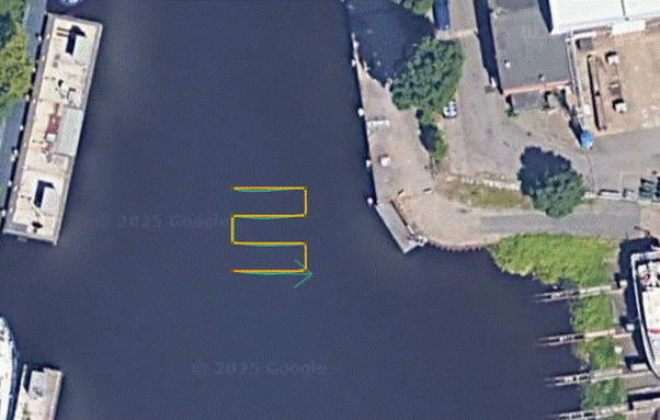
Visualization of MiniTortuga performing an underwater scan in a lawnmower pattern, at the Hamburg pilot location. Photo generated by Mihalis Maer and Stefan Pirje, Hamburg, Germany, 2025. Google Maps are used as background.
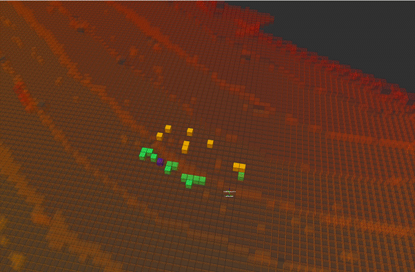
An example voxel grid map of the overall seafloor with marked litter, where the opaque-colored voxels are litter and the color is related to the elevation of the voxel. Photo generated by David Rete, Marseille, France, 2025.
Toward Cleaner Seas
SeaClear2.0 shows that tackling underwater pollution doesn’t have to require more manual effort — it can be done with better technology. By automating the detection and mapping of marine litter, this project offers tools that can empower civil society, researchers, and local governments to monitor and clean up their waters more effectively.